

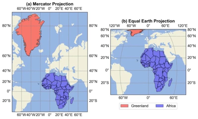
The document was voted on by 164 countries. The United States opposed it, while six other countries — Estonia, Georgia, Lithuania, Moldova, Serbia, and Ukraine — abstained. However, this is not about banning familiar maps. The resolution is advisory in nature: the UN suggests that states, international organizations, and its own structures actively use maps that depict the areas of countries and continents without significant distortions. ### Why the Familiar Map "Deceives" One of the most common world maps is based on the Mercator projection, developed by Flemish cartographer Gerard Mercator in the 16th century. It turned out to be extremely convenient for navigation, as it preserves directions and angles well. But it has a significant drawback: the farther a territory is from the equator, the more its image is enlarged. Because of this, Russia, Canada, Europe, and especially Greenland appear disproportionately large. Territories near the equator, primarily Africa and South America, seem smaller than they should in comparison. The most famous example is Greenland. On some familiar maps, it appears almost comparable in size to Africa. In reality, Africa's area is about 30.3 million square kilometers — it is approximately 14 times larger than Greenland. ### What the New Map Will Look Like One alternative is the Equal Earth projection, created in 2018. Its main feature is the preservation of the correct area ratios. On such a map, Africa appears much more impressive than on the Mercator map. South America, India, and other territories closer to the equator become more prominent. Meanwhile, Greenland, Canada, Russia, and European countries visually shrink. Of course, the actual sizes of states do not change. Only the way the Earth's surface is represented on a plane changes. Moreover, it is fundamentally impossible to create a completely accurate flat map. The globe must be "unfolded" onto a plane, so any projection inevitably distorts either areas, or shapes, or distances and directions. ### Why Africa Raised the Issue The initiative is called Correct the Map. The draft resolution was submitted by Togo on behalf of the African group with the support of the African Union. Proponents of the initiative believe that it is not just about geography. Maps influence how people perceive the sizes and significance of different parts of the world. In their opinion, centuries of dominance of the Mercator projection visually diminished Africa while simultaneously enlarging Europe and other northern territories. As reported by the Spanish agency EFE, Togo's Foreign Minister Robert Dussey emphasized that this is about the need for a more equitable representation of the world. ### The US Opposed Notably, the United States became the only country to vote against the resolution. The American delegation criticized the political component of the initiative, linking it to concepts of historical and "cognitive" justice. France, on the other hand, supported the idea of revising familiar cartography. As Le Monde reports, Paris has already announced a transition in official cartography from the Mercator projection to the equal-area Eckert IV projection, which also significantly more accurately conveys area ratios. ### Will School Maps Need to Change? There will not be an immediate replacement of all atlases and maps. The General Assembly's decision does not obligate countries to abandon the Mercator projection. However, the resolution may accelerate a process that is already underway among cartographers, scientists, and international organizations. Equal-area projections may increasingly be used in UN documents, government institutions, media, and educational materials. Therefore, the world map that future generations of schoolchildren will see may indeed differ significantly from the one that is familiar today. Africa will appear much larger on it, Greenland much smaller, and familiar perceptions of the sizes of certain countries and continents will need to be reconsidered.
