

 Foto: BB.LV / Земля
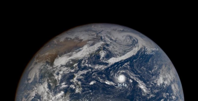
### Unusually Shaped Super Typhoon Captured in NASA Images Since April 2026, there has been increased activity of tropical cyclones in the northwestern part of the Pacific Ocean. The particularly tumultuous season was kicked off by Sinlaku, which intensified into a super typhoon and affected Micronesia, Guam, and the Northern Mariana Islands, reports [NASA](https://science.nasa.gov/earth/earth-observatory/the-pacifics-busy-storm-season/). Following it, another 25 storms formed in the region, each receiving its own name. However, by the end of October, the season showed no signs of winding down. On October 29, the EPIC camera aboard the DSCOVR satellite captured super typhoon In-fa near the Mariana Islands. It became the fifth typhoon to impact the archipelago this year. The next day, NASA's Terra satellite obtained a more detailed image of the storm, which had by then moved west of the island chain. Scientists were drawn to the unusual structure of the cyclone: an almost perfectly round shape, a large, well-defined eye, and the absence of the characteristic external spiral bands of clouds typical of most typhoons. ### Why Such Typhoons Are Called ‘Doughnuts’ In-fa exhibited signs of a rare variety of tropical cyclones known as annular cyclones. Unlike regular typhoons, which have long spiral bands of rain clouds radiating from the center, annular cyclones have a more symmetrical structure. In satellite images, they indeed resemble a giant doughnut or a car tire.  Annular typhoons are characterized by their nearly round shape and large, well-defined eye. Such storms occur relatively rarely. According to one study, they account for only about 4% of tropical cyclones in the western part of the northern Pacific Ocean. Annular typhoons have several distinctive features: - The average eye diameter is about 45 kilometers, while for regular tropical cyclones, it is approximately 25 kilometers. - The cloud structure is more symmetrical, and the external spiral bands are less pronounced. - Such cyclones can maintain their intensity longer even under deteriorating conditions for their existence. It is this last property that makes annular typhoons particularly interesting to meteorologists trying to forecast changes in storm strength. ### Typhoon with Winds Close to 300 km/h Reaches Alaska While In-fa was near the Mariana Islands, another powerful typhoon — Champi — was completing its journey across the Pacific Ocean. At its peak intensity, its sustained wind speed approached 300 kilometers per hour (approximately 83.33 meters per second), making it one of the most powerful storms of the season. Champi passed near Taiwan and Guam, and its effects were also felt in parts of China and Japan. The storm brought strong winds and heavy rainfall. Later, its remnants headed towards Alaska, but by that time, the system had already changed significantly. The tropical cyclone transformed into an extratropical storm — a phenomenon that meteorologists refer to as extratropical transition. ### How a Tropical Typhoon Becomes Another Storm Tropical cyclones derive their energy primarily from warm ocean water. Their structure is characterized by a warm core, with heat and moisture serving as the main energy sources. Extratropical cyclones are structured differently: they form and intensify due to temperature contrasts between different air masses. During the transition from one type to another, a storm can change shape, increase in size, and form atmospheric fronts. According to Gary Partica, a meteorologist at NASA's Goddard Space Flight Center, one sign of such a transformation is the expansion of the storm wind field. This does not necessarily mean an increase in maximum wind speed. However, strong winds begin to affect a much larger area. In the case of Champi, its remnants apparently merged with an already forming storm system over the Bering Sea and contributed to its intensification. Alaska managed to avoid catastrophic consequences similar to the destruction caused by the former typhoon Halong in October 2025. Nevertheless, strong winds, heavy rains, and significant snowfall were reported in certain areas. ### Four Former Typhoons in One Year — An Unusual Indicator for Alaska According to Rick Thoman, a meteorologist and climatologist at the University of Alaska Fairbanks, Champi became the fourth former typhoon to reach Alaskan waters in 2026. Before it, the region experienced the effects of three other systems: - Bang-lang — in August. - Dudjuan — in September. - Choiwan — in early October. In comparison, in the fall of 1997 and 2015, when particularly strong El Niño events were observed in the Pacific Ocean, three former typhoons reached Alaska. Overall, according to Thoman's data, about 60 such storms have impacted the region since 1970. ### What Does El Niño Have to Do with It Scientists suggest that one of the reasons for the unusual activity of typhoons in 2026 may be a strong El Niño. This climatic phenomenon occurs approximately every two to seven years and is associated with the warming of surface waters in the equatorial part of the Pacific Ocean. El Niño affects atmospheric circulation and can alter the trajectories of tropical cyclones. In particular, some studies indicate that under such conditions, typhoons in the northwestern Pacific Ocean are more likely to turn north instead of predominantly moving west. As a result, the likelihood of their movement towards Guam, the Northern Mariana Islands, Japan, and the Korean Peninsula increases. Gary Partica characterized the current season as particularly active and noted that the large number of tropical cyclones increases the likelihood of former typhoons in the Alaskan region. At the same time, El Niño is considered one of the possible factors, rather than the sole explanation for what is happening.
